Drones play a crucial role in advancing weather forecasting, particularly within the field of meteorology. Referred to as meteodrones, these specially designed unmanned aerial vehicles (UAVs) are equipped with sensors to gather data on temperature, humidity, and wind within the earth’s lowest atmospheric layer, known as the boundary layer. This data collection is pivotal for refining weather forecast models, providing meteorologists with more precise and timely information, and ultimately enhancing decision-making across diverse industries.
Advantages of Weather Drones
Compared to traditional meteorological data collection methods like weather balloons, weather drones offer several advantages. They boast enhanced maneuverability, better resistance to sudden changes in wind, and improved capabilities for capturing vertical column data crucial for weather forecasting. Weather drones excel at taking measurements in close proximity to buildings, structures, urban environments, and challenging offshore conditions. Beyond forecasting, they find applications in storm and hurricane tracking, long-term climate change research, and various other fields.
How Weather Drones Work
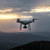
Weather drones operate by navigating into the boundary layer of the earth’s atmosphere and utilizing specialized sensors and video cameras to collect data. Meteorologists analyze this information to refine forecast models and deliver more accurate and timely predictions. Weather drones also serve in surveying and documenting damage post-disastrous weather events, aiding in preparedness for future risks and improved prediction capabilities. They address weather data deserts by enhancing access to weather information in regions lacking proper forecasting infrastructure.
Challenges and Future Developments
While weather drones offer numerous benefits, challenges include their flyability in specific weather conditions and the need for reliable, scientifically sound data collection methods. Ongoing projects aim to enhance drone utilization for weather data collection, potentially revolutionizing meteorological science. Initiatives include short-term field studies focusing on specific regions to understand the impact of terrain and land surface features on weather patterns. Additionally, there’s the development of a nationwide network of weather station towers, each equipped with a fleet of autonomous weather drones.
In conclusion, weather drones are reshaping meteorology by providing meteorologists with more accurate and timely data. Their ability to collect data in the earth’s lowest atmospheric layer and diverse environmental conditions makes them invaluable for various applications, ranging from day-to-day weather forecasting to storm tracking, hurricane prediction, and long-term climate change research. As technology evolves, weather drones are anticipated to play an increasingly crucial role in offering reliable and scientifically sound weather observations for diverse industries and applications.